Background
Lake Tana, the source of the Blue Nile and the Ethiopia’s largest natural buffer against seasonal variations of the rainfall patterns. Assessing the interactions between the Lake level fluctuation, hydroclimatic variabilities and anthropogenic factors is essential to detect drought conditions and identify the role of human management in controlling the Lake water balance.
Objective
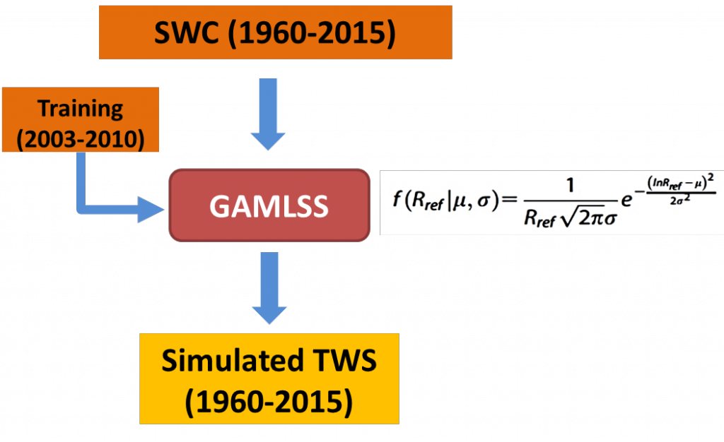
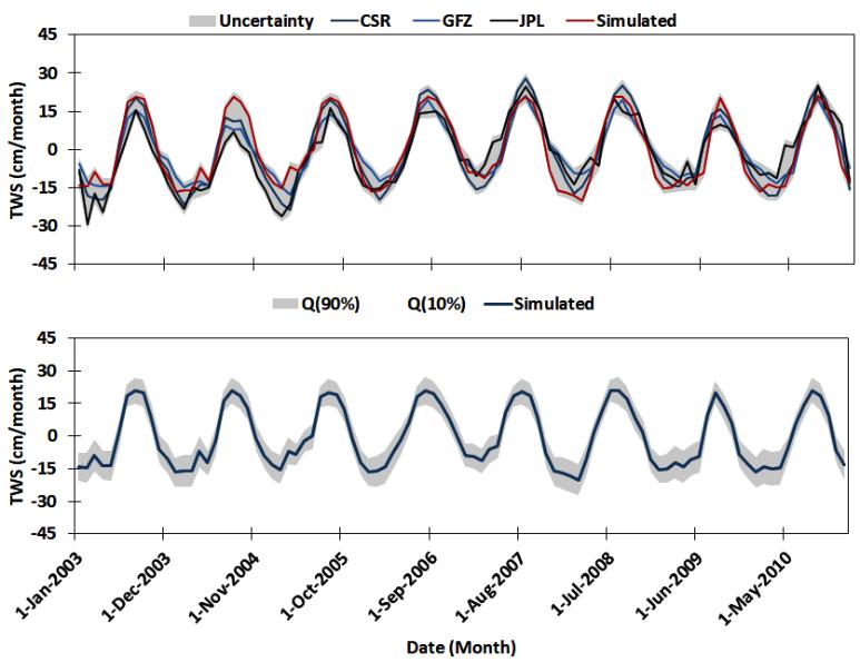
Via an extended record of Total Water Storage (TWS) anomalies between 1960-2016, a water budget model for the Lake water inflow/outflow was developed. Estimates of Lake Level Altimetry (LLA) of in-situ and satellite altimetry were composited from 1960-2016 and compared to the extended TWS anomalies, the self-calibrated Palmer Drought Severity Index (scPDSI), the El Niño Southern Oscillation (ENSO) and the historical Lake water releases.
Initial Results
The TWS anomalies are directly linked to the water budget estimates, the Lake level anomalies and to levels estimated by the model. Given these different types of data, the water budget of the Lake has monitored, the drought conditions can be identified the role of human management in the Lake can be determined. For instances, three major drought periods were identified, the 1970 to1977, 1979 to 1987 and 1990 to 1998, each period was succeeded with an interposed flooding related recovery year, i.e. 1978, 1988 and 1999. The drought/flooding events were derived mainly due to the ENSO interactions that fluctuated the Lake Levels. The period from 2002-2006 was associated with remarkable decline of the Lake level due to a surge in the amount of water releases due to the anthropogenic demands. The interaction between groundwater aquifer and the Lake is altered due to the unstable hydroclimatic conditions and the recent anthropogenic factors.
Dissemination
Hasan, E. Z. Dokou, P. E. Kirstetter, A. Tarhule, E. N. Anagnostou, A. C. Bagtzoglou, Y. Hong (2017). Assessing Lake Level Variability and Water Availability in Lake Tana, Ethiopia using a Groundwater Flow Model and GRACE Satellite Data. Abs. 263588. American Geophysical Union, New Orleans, Louisiana, Dec 11-15, 2017.
Research Team
Emad Hasan, Research Associate, Department of Geography, State University of New York (SUNY), Binghamton, NY
Zoi Dokou, Assistant Research Professor of Civil and Environmental Engineering, University of Connecticut.
Mohsen Kheirabadi, Graduate Student, Civil and Environmental Engineering, University of Connecticut.
Pierre Kirstetter, Research Scientist, Advanced Radar Research Center, University of Oklahoma, Norman, OK.
Aondover Tarhule, Professor, Department of Geography, State University of New York (SUNY), Binghamton, NY
Emmanouil N. Anagnostou, Professor of Civil and Environmental Engineering, University of Connecticut.
Amvrossios C. Bagtzoglou, Professor of Civil and Environmental Engineering, University of Connecticut.
Yang Hong, Professor, Civil and Environmental Engineering, University of Oklahoma, Norman, OK