Background
Ethiopia has an estimated groundwater (GW) potential of over two billion m³, which has the capacity to buffer vulnerability induced by climatic variability and foster human development linked to the water, food, and energy nexus. Lack of information and knowledge on the availability and sustainable use of GW resources, however, has constrained the country’s integrated development initiatives, leading to an insignificant GW-fed irrigation contribution (<3% of cultivated lands) and pushing the country’s 85% agriculture-dependent population toward water and food insecurity.
Objective
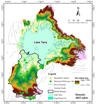
In this study, we developed a fine-resolution (500-m) GW model using MODFLOW-NWT, fed with daily distributed input forcings of recharge and streamflow simulated by the CREST hydrological model, for a spatial domain encompassing the Gilgel Abay (G-A) river catchment. We calibrated the model against instantaneous observations of GW depth for 38 historical wells by adjusting hydraulic conductivity, unit streambed conductance, specific yield, and recharge-to-infiltration ratio. To address the scarcity of in situ data, we validated the model at multiple well locations, using data collected from the PIRE Citizen Science Initiative (PIRE CSI) at three field sites at Kudmi, Dangishta, and Gaita. We also used data from the Innovation Lab for Small Scale Irrigation (ILSSI) project in Daingishta.
Initial Results
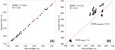
We obtained the calibration RMSE as 15.06m (1.8% of range) and the validation RMSE for the PIRE CSI and ILSSI sites respectively, as 18.21m and 15.76m. Furthermore, the MREs and NCRMSEs for both calibration and validation were less than 1% (normalized against mean observations), indicating a strong fit of the model to the available water table depth observations. The findings of this research also indicated a substantial potential for subsurface water resources in the Gilgel Abay region.
Dissemination
Dokou Z., Khadim, F.K., Bagtzoglou A.C., Anagnostou E.N., and Lazin, R. Development of a Calibrated Groundwater Model in an In-situ Data Scarce Region of the Upper Blue Nile, AGU Fall Meeting 2018, 9-14 December, Washington D.C., USA.